



Newer storm update, added 10:22 a.m. CDT Friday, Oct. 9: Isaias is now a Category 3 hurricane, and NWS Birmingham has issued a High Wind Warning for Blount County along with a Flood Watch. The storm information in this story is from Thursday and is out of date. See our latest hurricane update.
Updated 9:40 p.m. CDT Thursday, Oct. 8: The West Blount Corn Maze has postponed Market at the Maze, set for Saturday, to Nov. 7. The storm information in this story is from the hurricane center’s 4 p.m. CDT advisory (No. 9).
Updated 5:21 p.m. CDT Thursday, Oct. 8: Isaias has strengthened to 100 mph. National Weather Service Birmingham has issued a High Wind Watch for Blount County, with gusts up to 50 mph possible from late Friday night through late Saturday night, and a Flood Watch for all of Central Alabama from Friday evening through Sunday morning. Tropical storm watches and warnings cover much of central Alabama south of Blount County. The Covered Bridge Festival in Oneonta is canceled, and the Smoke Rise yard sale is postponed. See our list of cancellations and postponements.
Hurricane Isaias, with winds of 100 mph, is forecast to reach about 110 mph over the Gulf early Friday, one mph short of major hurricane strength. The National Hurricane Center expects it to make landfall on the northern Gulf Coast late Friday or early Saturday, and forecasts the center to be inland near the Alabama-Florida line by 1 a.m. Saturday as a 75 mph hurricane. It is then forecast to move north across western Alabama on Saturday, west of Blount County.

As of the hurricane center’s 4 p.m. CDT advisory Thursday (No. 9), Isaias was about 325 miles south of the mouth of the Mississippi River, moving northeast at 12 mph, with a minimum pressure of 975 millibars. Hurricane Hunter aircraft found 100 mph winds, up from 85 mph at 10 a.m. The advisory said preparations in the warning area should be rushed to completion today.
Warnings and the coast
A hurricane warning covers the coast from Ocean Springs, Miss., to the Bay-Gulf county line in Florida, which includes Mobile Bay and the Alabama coast. Tropical storm warnings cover the coast from the Jefferson-Plaquemines Parish line in Louisiana to west of Ocean Springs, and from east of the Bay-Gulf county line to the Aucilla River in Florida. A storm surge warning runs from the mouth of the Mississippi River to the Suwannee River in Florida. The hurricane center forecasts 5 to 7 feet of surge above ground from Ocean Springs to Indian Pass, Fla., including Mobile Bay.
Hurricane conditions are expected in the warning area Friday night into early Saturday, with tropical storm conditions beginning Friday. From Friday through the weekend the hurricane center forecasts 4 to 8 inches of rain across southern Alabama, the Florida Panhandle and Big Bend, and southwest Georgia, with localized totals up to 15 inches, particularly in bands across the Florida Panhandle and Big Bend.
The forecast track and strength
Isaias made its expected turn to the northeast Thursday and is forecast to turn north on Friday. After landfall the weakening storm is forecast to move north across western Alabama on Saturday and be near the Alabama-Tennessee line by early Sunday. The hurricane center nudged its forecast slightly east at 4 p.m. and said it follows the latest consensus of its best-performing models.

The official forecast has 110 mph around 1 a.m. Friday, 100 mph at 1 p.m. Friday while the storm is still offshore, and about 75 mph at 1 a.m. Saturday with the center inland near the Alabama-Florida line. It then weakens quickly over land, to about 35 mph over west-central Alabama, near Tuscaloosa, by 1 p.m. Saturday. A major hurricane is Category 3 or stronger, with winds of 111 mph or more.
The hurricane center called the intensity forecast “somewhat problematic.” The storm is over very warm, deep Gulf water and its track passes near a warm eddy overnight, so more strengthening is expected overnight, and the official forecast is at the high end of the computer models. But wind shear, already significant, is forecast to increase substantially over the next 36 hours, so some weakening is forecast as the storm nears the coast. Forecasters said Isaias is expected to remain a dangerous hurricane through landfall, with strong, gusty winds well inland after the center crosses the coast.
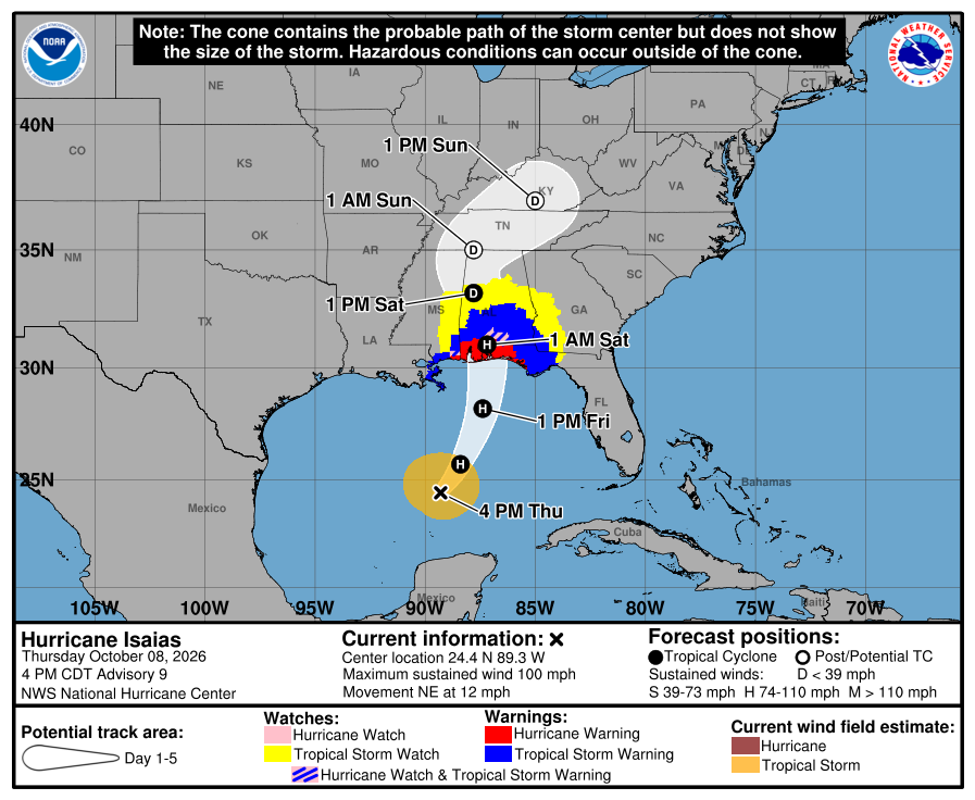
How to read the cone
The shaded cone shows where the center of the storm is likely to travel. It is drawn so the center stays inside it about two-thirds of the time. It does not show the size of the storm, and rain, wind, storm surge and tornadoes can reach well outside it. Warnings and watches now extend inland, shown in red, blue and yellow on the graphic. By our reading of the graphic, west Blount County is near the cone’s eastern edge on Saturday afternoon and evening.
What it could mean for west Blount County
By our estimate from the hurricane center’s forecast points, the center passes about 55 to 60 miles west of Hayden at its closest on Saturday afternoon. That puts west Blount County east of the center, on the side where heavy rain and brief tornadoes are the main local concerns.

National Weather Service Birmingham has issued a High Wind Watch for Blount County from late Friday night through late Saturday night. It says east winds of 15 to 20 mph with gusts up to 50 mph are possible, which could blow down trees and power lines and cause widespread power outages, and that travel could be difficult, especially for high-profile vehicles. In its 4:15 p.m. local statement the weather service said gusts will reach 40 to 50 mph late Friday night through Saturday, with isolated gusts to 60 mph. It rated the wind impacts as significant in southern parts of Central Alabama and at higher elevations, and limited in the rest of Central Alabama.
Tropical storm warnings are now in effect for south-central Alabama counties including Montgomery, and a Tropical Storm Watch covers Jefferson, St. Clair, Shelby and Tuscaloosa counties. Blount County is not in a tropical storm watch or warning. As of about 5:20 p.m. Thursday, the High Wind Watch and the Flood Watch were the only watches in effect for the county.
A Flood Watch is in effect for all of Central Alabama from Friday evening through Sunday morning. The weather service says heavy rain moves in Friday night and may last into early Sunday morning, with 2 to 4 inches and locally up to 5 inches, which could cause flash flooding, especially in urban areas and places with poor drainage. It rated the flooding rain impacts as significant, saying creeks and small streams could overflow and some roads and bridges could close. Forecasters said earlier Thursday that the ongoing drought has left streams low, which should limit widespread river flooding. The forecast for the Hayden area has a 100% chance of rain Friday night, 100% Saturday, 90% Saturday night and 40% Sunday, with southeast wind of 15 to 30 mph on Saturday.
The hurricane center says an isolated tornado risk begins Friday night in coastal Alabama, the Florida Panhandle and far southwestern Georgia, and continues Saturday for eastern Alabama, Georgia and the Florida Panhandle. National Weather Service Birmingham says isolated tornadoes may develop Saturday mainly east of Interstate 65, which passes through west Blount County. It rated its confidence as low to medium and said the impacts could be significant in eastern parts of Central Alabama if one occurs. The Storm Prediction Center’s Saturday outlook, updated at 2:30 p.m. Thursday, shows only general thunderstorms for the Hayden area.

These forecasts have shifted several times since Wednesday and will keep changing as the storm nears the coast.
Weekend plans
Three local events have changed. The Blount-Oneonta Chamber of Commerce canceled the Covered Bridge Festival in downtown Oneonta, set for Saturday, Oct. 10, the Smoke Rise Community Yard Sale has been postponed to Saturday, Oct. 24, and the West Blount Corn Maze has postponed Market at the Maze from Saturday to Saturday, Nov. 7. Friends of the Locust Fork River’s fall hike at Swann Covered Bridge, part of the festival’s schedule, is expected to be canceled as well. Our cancellations and postponements list has details and will be updated.
Saturday is forecast to be the wettest and windiest day in the Hayden area. Blount County Schools are not closing Friday. Hayden football at Guntersville is still set for 7 p.m. Friday, and the National Weather Service forecast for Guntersville shows no rain through 11 p.m., with rain arriving after 1 a.m. Saturday. Frightful Fridays at Rickwood Caverns State Park is at 4 p.m. Friday.
The West Blount Corn Maze’s regular hours are Fridays 4 to 10 p.m., Saturdays 10 a.m. to 10 p.m. and Sundays 1 to 6 p.m. The maze is extending its season one more weekend, Saturday and Sunday, Nov. 7 and 8. Check with each organizer for the latest before heading out. If an event you know about has changed, send it in at westblount.com/submit and we will update the calendar.

Getting ready
The hurricane center advises residents of central and northern Alabama to secure loose outdoor items, avoid driving high-profile vehicles and prepare for power outages. The weather service adds that people near large trees or in mobile or manufactured homes should plan to move to safe shelter, that people in low-lying or poor-drainage areas, in valleys or near swollen rivers should plan to move to higher ground, and that everyone should have multiple ways to receive tornado warnings and be ready to shelter quickly. Other standard preparations from the National Weather Service and Ready.gov: charge phones and a battery-powered weather radio, and avoid driving through flooded roads. If you have family or travel plans on the Alabama, Mississippi or Florida Panhandle coast, follow local emergency management instructions.
This story was last updated at 9:40 p.m. CDT Thursday, Oct. 8, to reflect the postponement of Market at the Maze. Storm information is from the hurricane center’s 4 p.m. CDT advisory (No. 9) and National Weather Service Birmingham’s alerts and 4:15 p.m. local statement. Newer advisories have been issued since then; see nhc.noaa.gov for the latest.
Corrections: An earlier version of this story, updated Thursday morning, said gusts of about 35 mph were forecast in the Hayden area and that the storm’s center would pass roughly 100 miles west. The 35 mph figure came from an automated forecast grid. National Weather Service forecasters say gusts of 40 to 50 mph are possible, and the hurricane center’s latest forecast puts the center about 55 to 60 miles west. That version also said the Storm Prediction Center had placed the Hayden area in a marginal risk for severe storms on Saturday. Its latest outlook shows only general thunderstorms there. An earlier version also said Market at the Maze was going on rain or shine, as its organizers had announced. The maze has since postponed it to Nov. 7.
Sources: National Hurricane Center public advisory, forecast discussion and forecast advisory for Isaias, advisory 9, 4 p.m. CDT Oct. 8 (nhc.noaa.gov); National Weather Service Birmingham alerts, area forecast discussion and tropical cyclone local statement, Oct. 8 (weather.gov/bmx); National Weather Service Huntsville forecast for Guntersville (weather.gov/hun); Storm Prediction Center (spc.noaa.gov).