



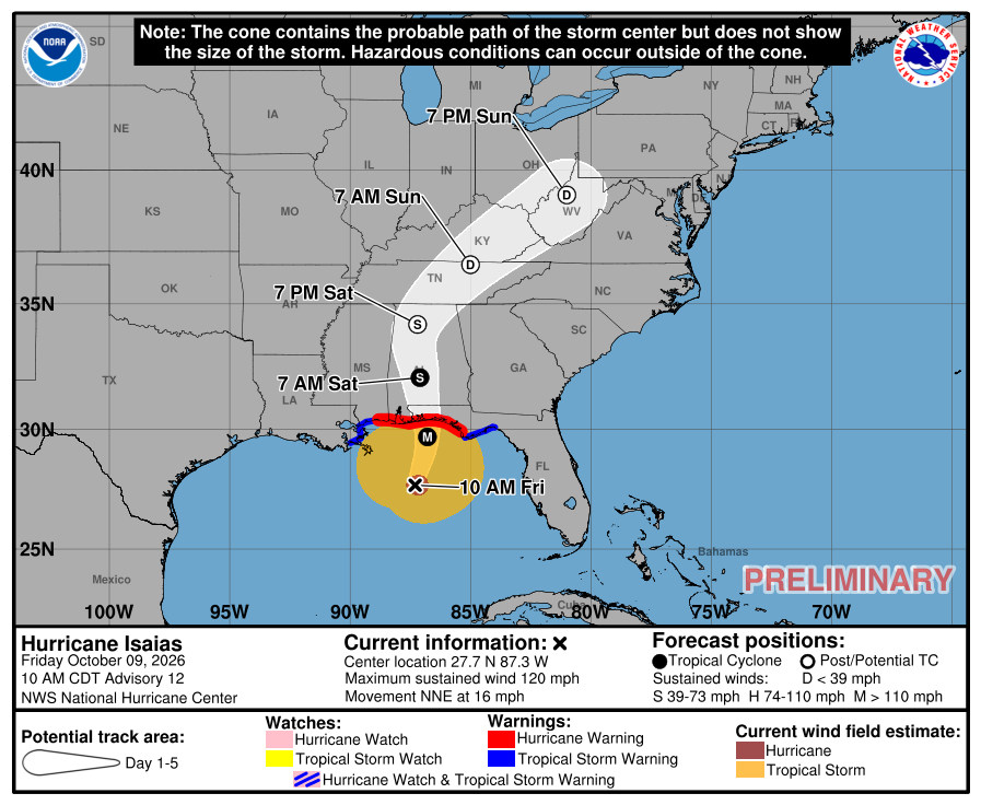
Updated 10:04 a.m. CDT Friday, Oct. 9: Isaias is a Category 3 hurricane with 120 mph winds, and the National Hurricane Center expects it to come ashore on the extreme western Florida Panhandle coast this evening. Forecasters say damaging wind gusts are likely across much of central and northern Alabama. The center is forecast to move north through Alabama on Saturday and pass about 25 miles west of Hayden at its closest, by our estimate from the hurricane center’s forecast points. NWS Birmingham upgraded the High Wind Watch for Blount County to a High Wind Warning at 9:53 a.m., and a Flood Watch is also in effect.
What changed since Thursday
Isaias had 105 mph winds at 10 p.m. Thursday. It strengthened overnight, and at 7:20 a.m. Friday a hurricane hunter aircraft measured 120 mph winds and a central pressure of 959 millibars, making Isaias a major hurricane, Category 3 on the Saffir-Simpson scale. The hurricane center said the winds and pressure have since leveled off and that Isaias is “expected to be at or near major hurricane strength when it makes landfall this evening.” Its official forecast has 115 mph winds just offshore at 7 p.m.
Strong wind shear, now 30 to 40 knots out of the southwest, would normally weaken a hurricane. The hurricane center said the shear vector is nearly aligned with the storm’s motion, which limits its adverse effects, and that upper-level divergence is increasing over the storm. That setup likely let Isaias intensify this morning, and several hurricane and statistical models suggest it could keep major hurricane strength up to landfall. The forecasters called this “a tenuous spot” in their earlier discussion, saying a delay of about six hours in the shear’s onset could bring a stronger hurricane onshore than expected.
The track also drifted east, and forecasters have raised their wind forecasts for inland Alabama. Weakening should begin after landfall, and the hurricane center expects Isaias to lose its tropical characteristics by late Saturday over northern Alabama.

Wind: the main threat for west Blount County
NWS Birmingham upgraded the High Wind Watch for Blount County to a High Wind Warning at 9:53 a.m. Friday. The warning runs from 1 a.m. Saturday to 1 a.m. Sunday. Its text says east winds of 15 to 25 mph with gusts up to 40 mph are expected, that damaging winds will blow down trees and power lines, that widespread power outages are expected, and that travel will be difficult, especially for high-profile vehicles. The warning covers Blount, Etowah, Calhoun, Cherokee and Cleburne counties.
The forecasters’ discussion, written earlier this morning, is more severe than the warning text. It says gusts of 50 to 60+ mph are possible across Central Alabama from late tonight through Saturday, enough for widespread downed trees and power lines, up from 40 to 50 mph in Thursday’s forecasts, and that the standard wind probabilities “appear a bit underdone” and “are not representative of the potential for damaging wind gusts.” Jefferson, St. Clair, Shelby and Tuscaloosa counties are under a Tropical Storm Watch instead. Forecasters used Interstate 20 as the rough dividing line between tropical storm and high wind products and said the difference matters little, because it will be windy either way.
The hurricane center goes further. Its discussion says sustained hurricane-force winds will likely occur near and along the track up to 100 miles inland into southern Alabama, and that “gusts to hurricane force could extend even farther north into central Alabama.” It lists damaging gusts as likely across much of central and northern Alabama, especially in higher terrain.
To keep those numbers in proportion: sustained hurricane-force winds, 74 mph or more, are expected to reach up to about 100 miles inland, which is southern Alabama, well south of Blount County. The hurricane center does not say how far north its hurricane-force gusts could reach, and it describes them as something that “could” happen. The local forecast from NWS Birmingham is for gusts of up to 40 mph in the warning text and 50 to 60+ mph in the forecasters’ discussion, which would still be damaging.

Gradient winds. Part of the danger comes from air pressure, not the storm’s core. High pressure to the east and northeast is pressing against the weakening storm, and that tight difference in pressure drives strong winds that can blow hard far from the center. NWS Birmingham said the gradient is why its wind probabilities look too low. NWS Huntsville said it has “extremely high confidence” the strong gradient wind field will remain a significant concern Saturday and Saturday night, with gusts of 30 to 50 mph plausible across the Tennessee Valley, and that strong wind shear will expand the gradient wind field as Isaias loses its tropical features.
A possible sting jet. As Isaias merges into an upper-level low and loses its tropical structure, forecasters are watching for a sting jet, a narrow stream of air that descends from high in the atmosphere to the surface within an intensifying low-pressure system. NWS Huntsville said Thursday it is monitoring for a “low chance” of 60 to 80 mph gusts as Isaias moves north into the Tennessee Valley, and that if one occurred there would be “an increased risk of swaths of intense wind damage and subsequent power outages.” AL.com reported that NWS Birmingham also warned a sting jet could affect central Alabama on Saturday, with a narrow corridor of 50 to 60 mph gusts along the storm’s track, and that sting jets are typically about 30 miles across and last three to four hours. Whether one forms, and where, is not known yet.
Timing. NWS Birmingham expects light to moderate rain to spread from south to north late this morning and afternoon, with gusty east winds beginning. Conditions then “quickly deteriorate” Friday night, with widespread rain by early evening and the worst winds from about midnight into Saturday morning. Winds ease from south to north through Saturday morning as the pressure gradient relaxes, but stay gusty through the day.
What it could do. The weather service’s 7:04 a.m. local statement rates the wind impacts as significant across Central Alabama: damage to roofing, siding, porches, carports and sheds, several large trees snapped or uprooted, some roads blocked by debris, and scattered power and communications outages, more prevalent where lines are above ground. Mobile and manufactured homes could be damaged, especially if unanchored.

Rain and flooding
A Flood Watch covers Blount County and the rest of Central Alabama from Friday evening through Sunday morning. NWS Birmingham forecasts 1.5 to 4 inches of rain, locally up to 5 inches, which could cause flash flooding, especially in urban, low-lying and poor-drainage areas. It rates the flooding impacts as significant: creeks and small streams could overflow, water could enter some structures, and some roads and bridges could close. Forecasters expect the heaviest rain overnight across west Alabama and the far southern counties, with another band near the Georgia line Saturday morning and lower totals between them, but kept the watch for the whole area.
The forecast for the Hayden area is a 100% chance of rain tonight and Saturday, with 1 to 2 inches possible in each period, and a 30% chance of showers early Sunday. The hurricane center says much of the Southeast could see 2 to 5 inches of rain through the weekend, with locally higher amounts up to 10 inches in the Southern Appalachians.
Tornadoes
The hurricane center says the tornado risk increases this afternoon and continues tonight, greatest east of the center across the Florida Panhandle into southern Georgia, then spreads north-northeast across the Southeast on Saturday. NWS Birmingham says isolated tornadoes may develop Saturday mainly along and east of Interstate 65, which passes through west Blount County, with the highest potential near the Georgia line. Eastern Alabama is in a level 1 to 2, out of 5, severe-weather risk, and the Hayden area was outside the Storm Prediction Center’s outlined risk area on its latest map. The weather service urges having multiple ways to receive tornado warnings.
The storm at the coast
A hurricane warning covers the coast from Ocean Springs, Miss., to the Bay-Gulf county line in Florida, and a storm surge warning runs from the mouth of the Mississippi River to the Suwannee River in Florida. The hurricane center forecasts 6 to 9 feet of surge above ground from the Alabama-Florida border to Grayton Beach, Fla., 4 to 6 feet from Dauphin Island to the Alabama-Florida border, and 3 to 5 feet in lower Mobile Bay. Hurricane-force winds extend up to 35 miles from the center and tropical-storm-force winds up to 205 miles. The hurricane center said the eye is now within range of coastal radars and that it will issue hourly updates starting at 11 a.m. CDT.

Watch it live
These are public cameras along the coast from Destin to Gulf Shores, listed east to west. The center is forecast to come ashore on the extreme western Florida Panhandle, so cameras from Okaloosa Island to Perdido Key are closest to it. Most are run by resorts, businesses or webcam sites, and cameras can go dark in a storm. We link to each camera’s own page and have not embedded them.
Destin. EarthCam aerial of Destin Harbor, East Pass and Crab Island; HarborWalk Village cams; Jetty East (Gulf and East Pass); Pompano Joe’s beach cam; more Destin cams on LiveBeaches.
Fort Walton Beach and Okaloosa Island. Okaloosa Island Pier underwater camera (county tourism office, YouTube); The Breakers beach cam; Holiday Inn Resort beach cam.
Navarre Beach. Navarre Beach Pier Live (24/7 on YouTube); Navarre Beach Life HD zoom cam; more Navarre cams, including an underwater cam.

Pensacola Beach and Pensacola. Visit Pensacola’s webcams (beach views, Quietwater Beach and more); the Santa Rosa Island Authority’s official Casino Beach cameras, which its site says are offline during the pier renovation; more Pensacola Beach cams, including the Fort Pickens National Park Service cam; a Pensacola Bay Bridge traffic cam; and the state’s Florida 511 traffic cameras.
Perdido Key. Mirabella Beach; La Riva Resort; the Perdido Key Entertainer cam on the Intracoastal Waterway; more Perdido Key cams.
Orange Beach. Perdido Pass and Alabama Point; Turquoise Place; Orange Beach beach cam and panorama; the Phoenix condo cams in Orange Beach and Gulf Shores; FOX10 Weather Cam; more Orange Beach cams.
Gulf Shores. Gulf Shores beach cam; Sea-N-Suds, on the pier at Boardwalk Condominiums; The Beach Club Resort and Spa; HDBeachCams; more Gulf Shores cams; and the state’s ALGO Traffic cameras for roads in Orange Beach and Gulf Shores.

For more, LiveBeaches lists Gulf Coast cameras by city, and Windfinder has a Fort Morgan view just west of Gulf Shores.
Cancellations and weekend plans
The Covered Bridge Festival in Oneonta is canceled, and the Smoke Rise Community Yard Sale and Market at the Maze are postponed. See our list of cancellations and postponements, and send us any change you hear about at westblount.com/submit.
Getting ready
The hurricane center advises people in central and northern Alabama to secure loose outdoor items, avoid driving high-profile vehicles, prepare for power outages and be aware of the potential for falling trees. NWS Birmingham adds that people near large trees or in mobile or manufactured homes should plan to move to safe shelter, that people in low-lying or poor-drainage areas, in valleys or near swollen rivers should plan to move to higher ground, and that outside preparations should be finished before conditions deteriorate, because strong gusts or flooding make them unsafe. Have multiple ways to receive tornado warnings, be ready to shelter quickly, and check on neighbors who may not be able to prepare. More is at Ready.gov.
This story was last updated at 10:04 a.m. CDT Friday, Oct. 9, with the hurricane center’s 10 a.m. CDT advisory (No. 12) and discussion, and National Weather Service Birmingham’s and Huntsville’s alerts and forecast discussions, including the High Wind Warning issued at 9:53 a.m. The hurricane center will issue hourly updates starting at 11 a.m., with its next full advisory at 4 p.m. NWS Birmingham’s next local statement is expected by 11 a.m.

Sources: National Hurricane Center advisory 12, tropical cyclone update and forecast discussion for Isaias, Oct. 9 (nhc.noaa.gov); National Weather Service Birmingham alerts, area forecast discussion and tropical cyclone local statement, Oct. 9 (weather.gov/bmx); National Weather Service Huntsville forecast discussion and “Potential for Sting Jet” graphic, Oct. 8-9 (weather.gov/hun); AL.com on the sting jet warning; Storm Prediction Center (spc.noaa.gov).