

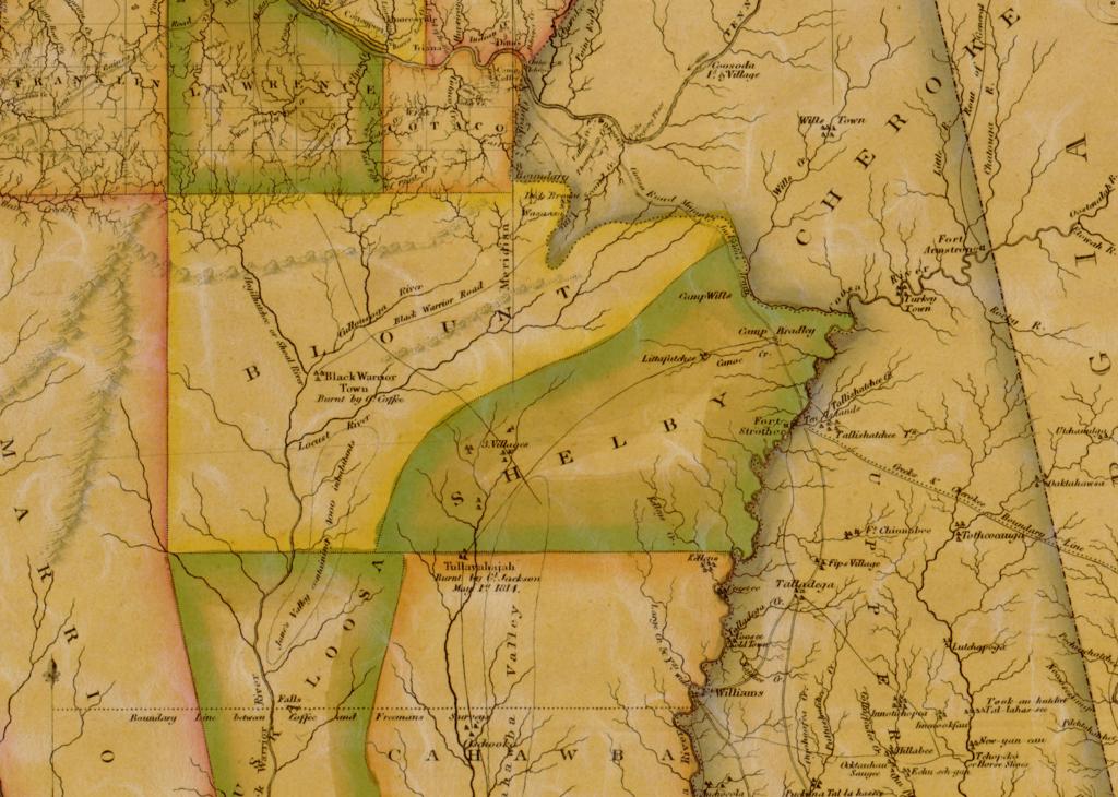
There is a line on an old map that I cannot stop looking at. It is a thin road, drawn in 1818, labeled in an engraver’s careful capitals: Black Warrior Road. It runs southwest across the territory that had just become Blount County, and it ends at a town that the same map says was “Burnt by Gl. Coffee.”
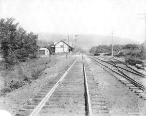
I live in what used to be called Brown’s Valley, a short walk from Reid’s Gap, on land the L&N railroad once crossed. The first time I saw that line, I did the thing you do when a map surprises you. I held my place on the screen and asked a plain question: where, exactly, did it go? That question has taken up a good part of my last year. This is the story of how I have gone after it, what I found, and what is still missing.
The map that started it
The map is John Melish’s Map of Alabama, constructed from the surveys in the General Land Office and other documents, published in Philadelphia in 1818, the year Blount County was created and a year before Alabama became a state. The Alabama Department of Archives and History has a digital copy, and that is where you can see it for yourself.
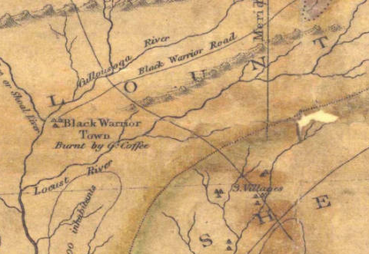
Three things grabbed me. First, the town is on the map by name, and the map says what happened to it. Five years after the burning, the destruction was still the thing a mapmaker wanted you to know about the place. Second, the road is lettered. Not every road on the map is. This one has a name, which tells me it was a known thing, something travelers and surveyors talked about. Third, and this is the one that kept me up, it is drawn as one road with one destination. It does not fork toward Jones Valley. It goes to the town.

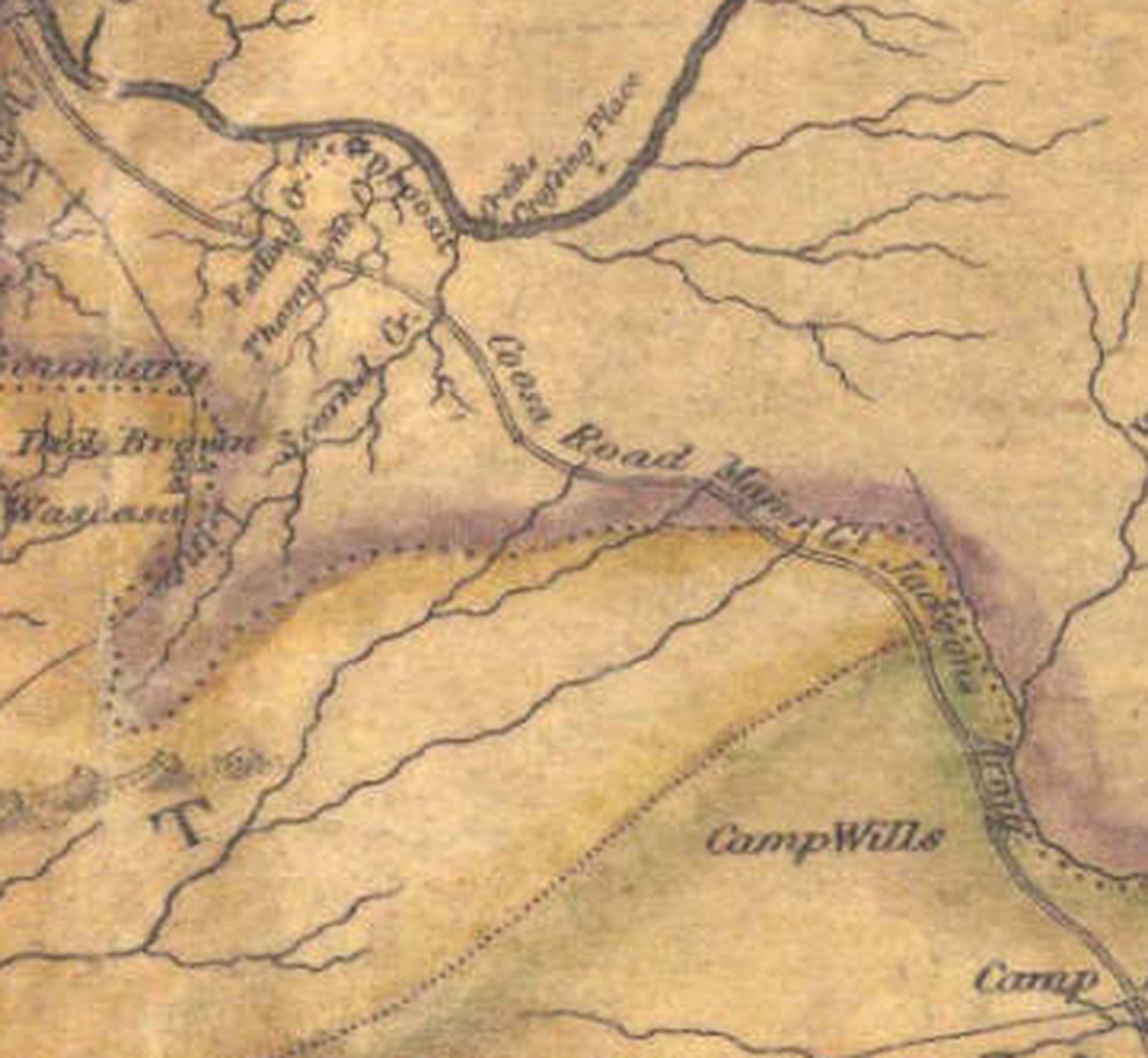
At the northeast end, where the road meets the Cherokee boundary, the map letters two names together: “Dick Brown” and “Wassausy.” Dick Brown was the Cherokee colonel for whom Brown’s Valley is named. Wassausy, I take it, is the Indian name for the Bear Meat Cabin settlement that became Blountsville. So the road’s head is the Brown’s Valley country, and the valley below it is where I live.
Who was here
To see why that road mattered, you have to see the country as the people in it saw it: a borderland. The Cherokee held the high valleys to the northeast. The Chickasaw and the Choctaw lay to the northwest and west. The Creek Nation, the Muscogee, held the broad country to the south and east, including the whole basin of the Black Warrior. The river itself was a kind of frontier. The Alabama Department of Environmental Management’s basin report says it was known in the 1700s as Apotaka hacha, the “border river,” because it marked the line between Choctaw, Chickasaw and Creek territory.
Black Warrior Town sat at the junction of the Sipsey and Mulberry forks, in what is now Walker County. The roadside marker erected there in 2017 by the Sipsey Heritage Commission calls it “one of the northernmost settlements of the Muscogee (Creek) Nation” and says it stood “at the border of Choctaw, Chickasaw and Creek territory,” a place “where members of these different tribes came together to trade and rest from hunting.” Three years after the burning, the U.S. commissioners who negotiated the 1816 treaties wrote in their report that the Creeks held settlements “at Black Warrior, a very old town.”
A town like that is also a destination, and a destination implies roads. The one that ran north from it toward the Tennessee River was the Black Warrior Road. I have written before about what happened to it afterward, in Black Warrior Road & the Creek Removal. What I could never get a straight answer to was the simple geographic question: which way did it run through this end of the county?

October 1813
The best evidence for the road comes from the man who burned the town. John Coffee left his camp on the Tennessee River, two miles above Ditto’s Landing, on October 14, 1813, with about 600 mounted Tennesseans. David Crockett rode with them. Coffee’s guide, one of the sons of a man named Melton, did not really know the country, but he “shewed me a path that had been reputed the Black Warriors path.”
In his report to Jackson on October 22, Coffee describes the march. They followed that path “about 10 degrees East of South” for 80 miles, then crossed a river about 60 yards wide running to the west. Beside it was a small deserted village, which another guide, Russell, said was Black Warrior’s town. Coffee, “being convinced it was not,” went on. He found a cross path “leading nearly west,” followed it 13 miles to a small village, burned the houses, took about 100 bushels of corn, and went 8 miles further to the main town, which was empty.
Writing to his wife two days after he got back, he put it in one line: “I burnt three towns but never saw an Indian.”
What strikes me now is that two men on the ground disagreed about which village was Black Warrior Town while the campaign was still going on. The confusion that people still have about this place goes back to the day it was burned. It also tells me something about the road. It was a real path with a real name, known to guides, and it ended at a place in the west. It did not turn south to Jones Valley.

The route everyone repeats
The usual account, the one you find in the reference works, runs the Black Warrior Road from Ditto’s Landing at Huntsville through Bear Meat Cabin at Blountsville, then south by Village Springs into Jones Valley and on to Mud Town on the Cahaba, with Black Warrior Town named as a stop on the way to the falls at Tuscaloosa. In 1818 that same corridor was surveyed and improved into the Huntsville Road, also called the Bear Meat Cabin Road or Stouts Road, and in 1822 it became a federal post road.
That is a real road, and a famous one. But it is a road toward Jones Valley and the Cahaba, built in the stagecoach era. Melish’s road, and Coffee’s path, end at the confluence of the Mulberry and the Sipsey. The more I looked, the more it seemed to me that two different roads had been folded together. I wanted to see if I could prove it.
Working the problem
I have no training for this. What I had was a stubborn habit: when a document gives you a place, a date and a name, go find the next document. Here is the trail.
1. The act that created the county
The Alabama territorial legislature created Blount County on February 6, 1818. The act describes it as the tract “bounded on the west by the Sipsey fork, to its junction with the Mulberry Fork of the Black Warrior; from thence by the united stream, to its junction with the Locust fork.” In other words, the town sat at the county’s own western corner. It also puts the first court “at the house of Maj. Kelly, in Jones Valley,” which means that for a short time in 1818 and 1819 the county reached all the way to what is now Birmingham.

2. The treaties and the Cherokee line
The Creek Nation ceded its land at Fort Jackson on August 9, 1814. The Cherokee gave up their claims to the Warrior country on September 14, 1816, in a treaty whose boundary begins at “Camp Coffee, on the south side of the Tennessee river,” the very camp where the 1813 raid started, and runs “due south” to the ridge dividing the Tennessee waters from the Warrior, “leaving the head waters of the Black Warrior to the right hand.” Richard Brown signed the ratification at Turkey Town. George Powell, writing in 1855, says the ridge runs through the county; the Warrior side was Creek country and he calls it “old Blount.” Brown’s Valley and Blountsville Valley, he writes, “are really the same,” divided only by a low watershed. That puts the part of the valley that drains to the Warrior, the part where I live, on the Creek side of the line, on the road and not off it. The story of Brown’s Valley is its own chapter.
3. The commissioners and General Jackson, 1816
The published American State Papers carry the commissioners’ report from the Chickasaw Council House on September 20, 1816. It says the Creeks “continued in possession until 1813, when they were driven away by the American troops” and names Black Warrior as “a very old town.” In a letter that June, Andrew Jackson refers to “the Creek village, on the Black Warrior, burnt by General Coffee,” as a landmark he can use to place a boundary. In three years the burning had become a point on the map.
4. The surveyors
Coffee became the surveyor general, and his men plotted every township. I pulled the plat for the township that contains Reid Gap.
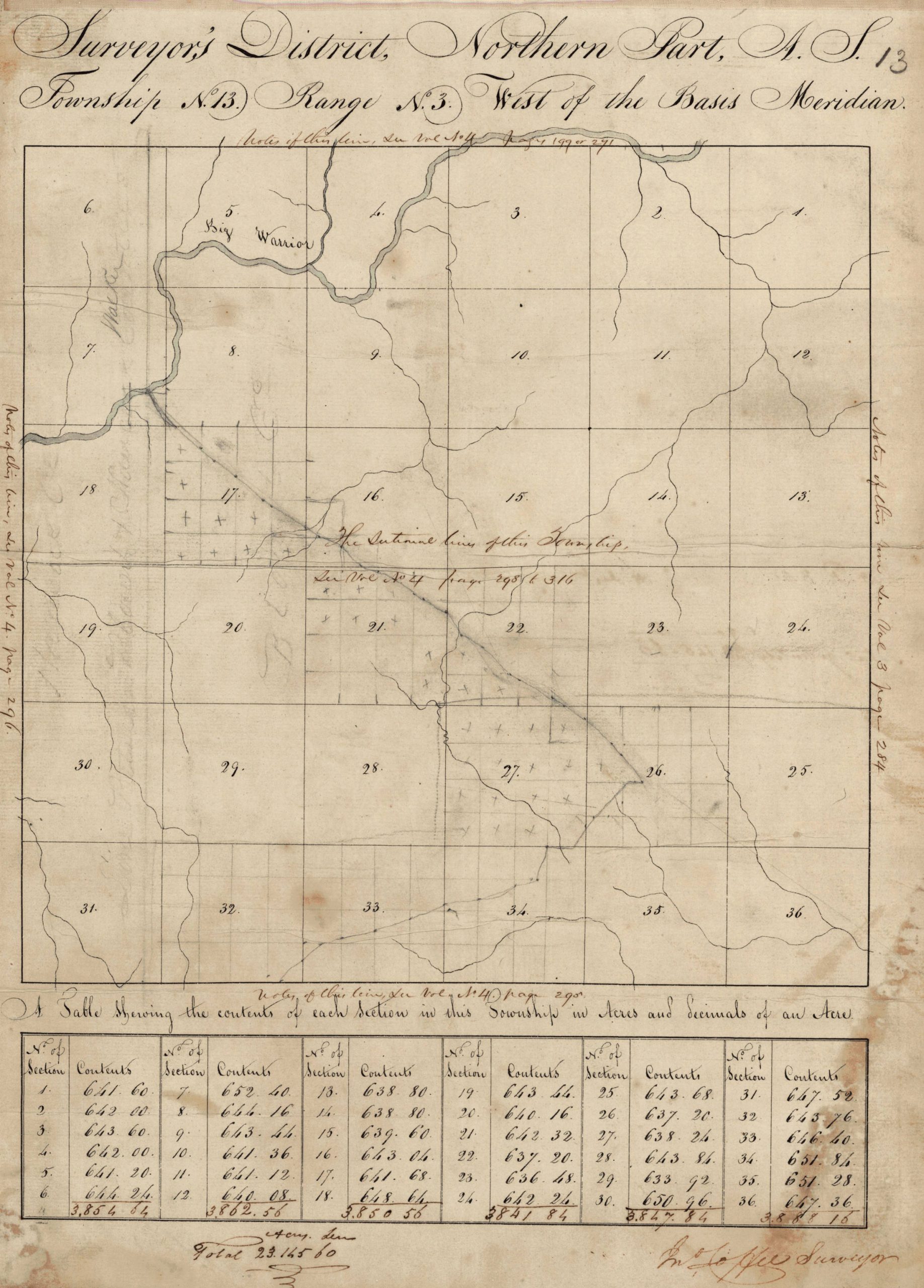
It shows no roads at all in ink; the original surveyors drew the streams, the section lines, and a river labeled “Big Warrior,” which is what they called the Mulberry Fork. Along the margins, in a clerk’s hand, are page numbers for the surveyors’ field notes: volumes 3 and 4, pages 284 through 316. Those are the notes where a man walking the section lines would have written down that he crossed a road. I do not have them yet.

What the plat does carry is a faint pencil line, with dots at regular intervals, that comes down from the river and angles toward the section that holds Reid Gap. I cannot tell you what it is. It could be an early road. It could be a railroad survey made in the 1850s when the South & North Alabama was choosing its way through here. The ink road and the railroad are the two things I would like to untangle, and I cannot do it from the plat alone.
5. A Civil War era map
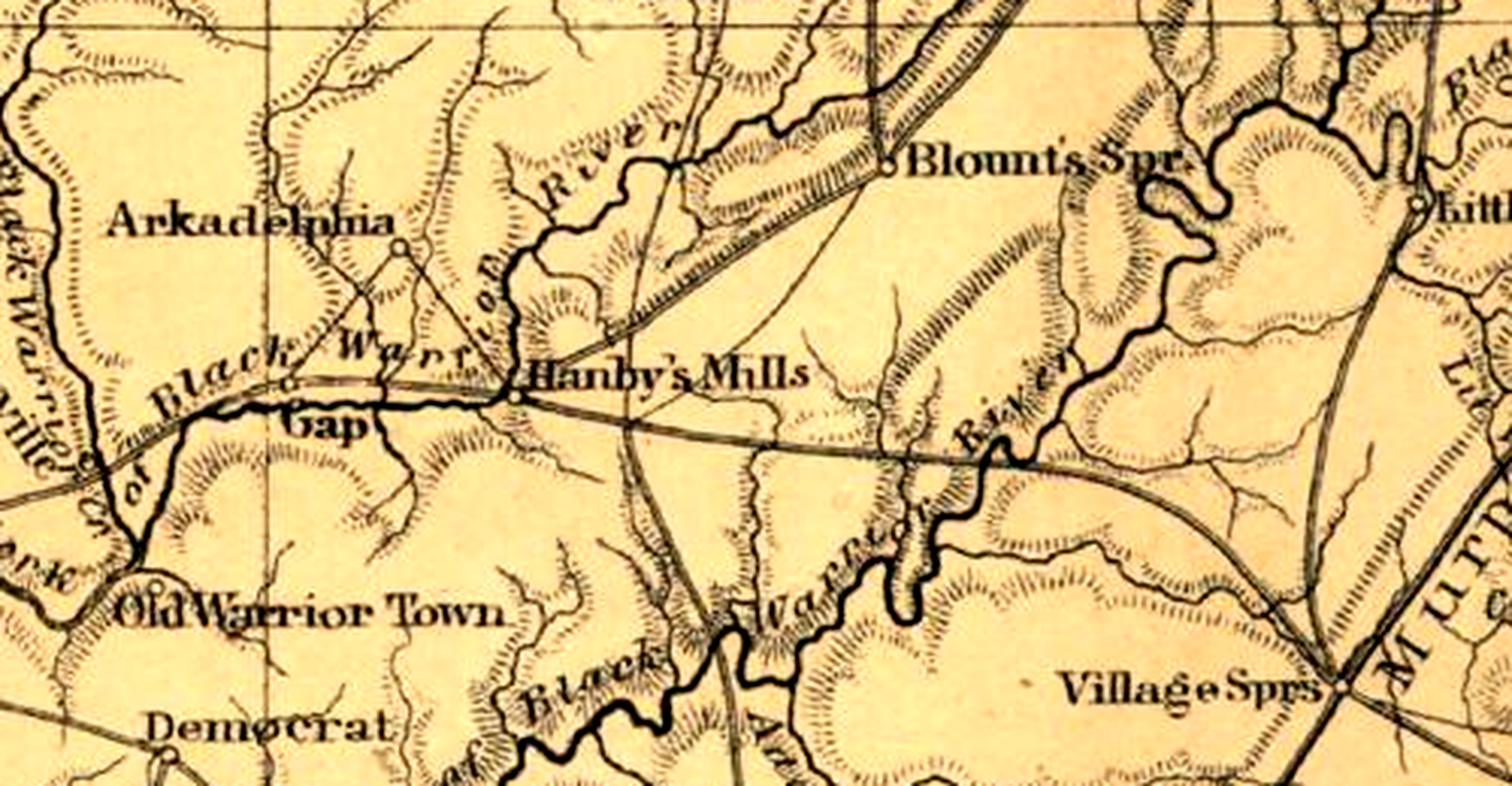
A map from about 1864 does what Melish did, forty-six years later. It labels “Old Warrior Town” at the elbow of the river. It draws a thin road from Blount’s Spr. southwest to the main road just east of Hanby’s Mills, and a main road that runs west through a place it calls “Gap” and across the river fork toward the town. When I fit that map to the modern ones, the town symbol lands within a mile of the 2017 marker. The old name had lasted half a century and sat in the right place.
6. The USGS, 1889
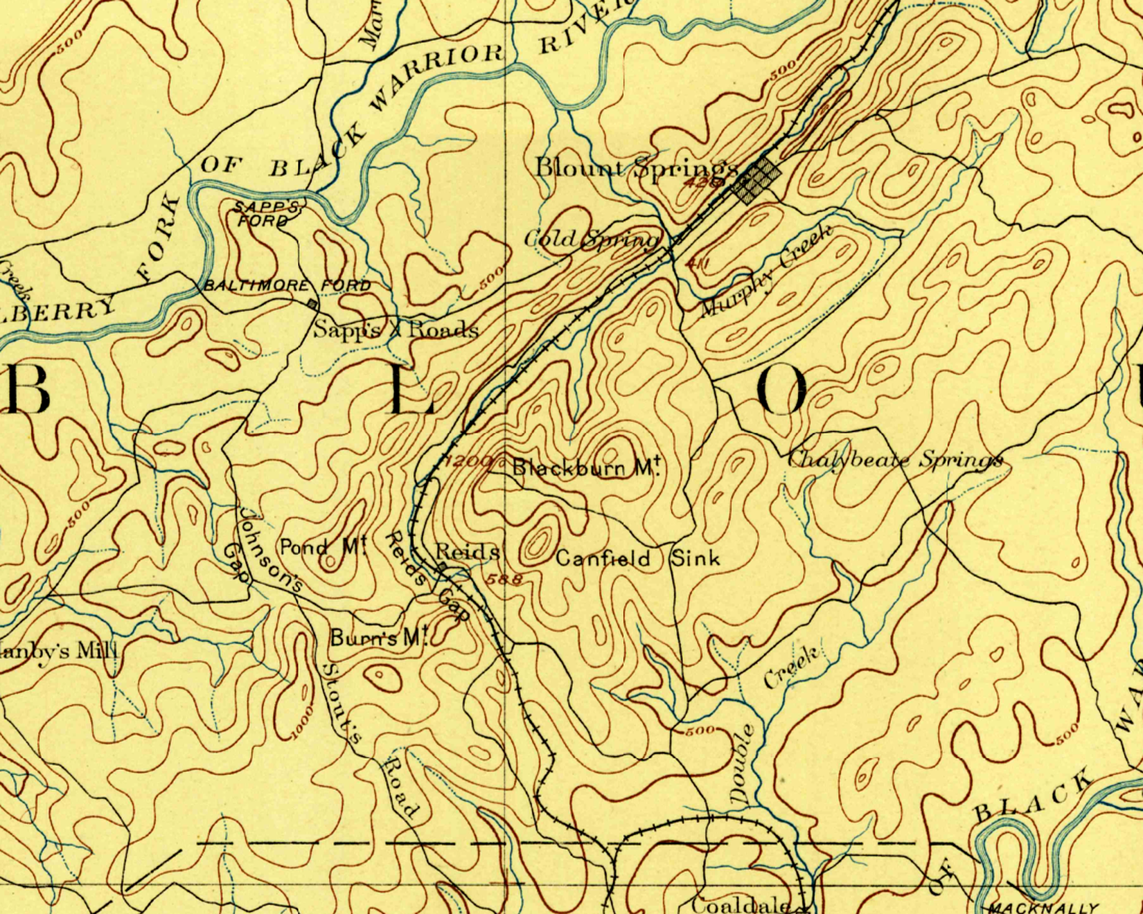
The U.S. Geological Survey’s early topographic sheet of this country, surveyed in 1887, is where it came together for me. You can see the L&N running down the valley on the northwest face of Blackburn Mountain (the hill we now call Bryant Mountain), bending around to a station called Reids, and turning south through Reids Gap. The old railroad grade I live beside is just before that bend.
The roads at Reids are what I had been looking for. One runs west along the north foot of Burn’s Mountain through a notch labeled Johnson’s Gap to Hanby’s Mill, which sits on the Mulberry with Sullivan’s Ford just beyond. Another, labeled Stout’s Road, comes down from Baltimore Ford and Sapp’s Crossroads and bends south along the mountain toward Warrior and the Jones Valley country. That is the stagecoach road. It does not use the valley by the railroad. It is a different road from the one that goes west.
7. Which side of the river
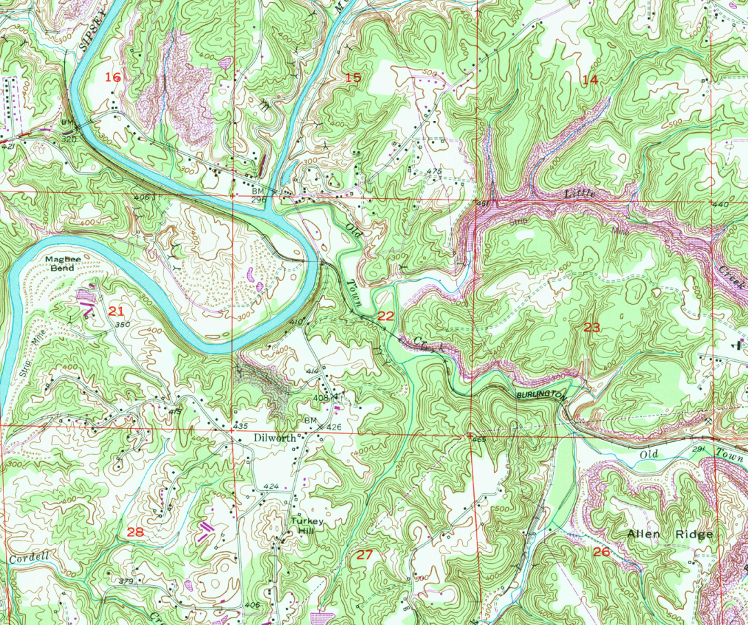
A road to the town from the Blount side of the Mulberry has to stay on the same bank as the town, or it gets a river crossing for free. I checked the hydrography. Blount Springs and Reid Gap are on the southeast bank of the Mulberry Fork. The old river town of Old Baltimore is on the northwest bank. So a road through Baltimore puts a traveler on the wrong side of the river for the town, which sat just south and east of the junction. The 1949 Sipsey quadrangle backs that up: a stream called Old Town Creek comes into the junction from the east and southeast, and the flat ground at its mouth is exactly where the old accounts put the town.
8. Letting the terrain vote
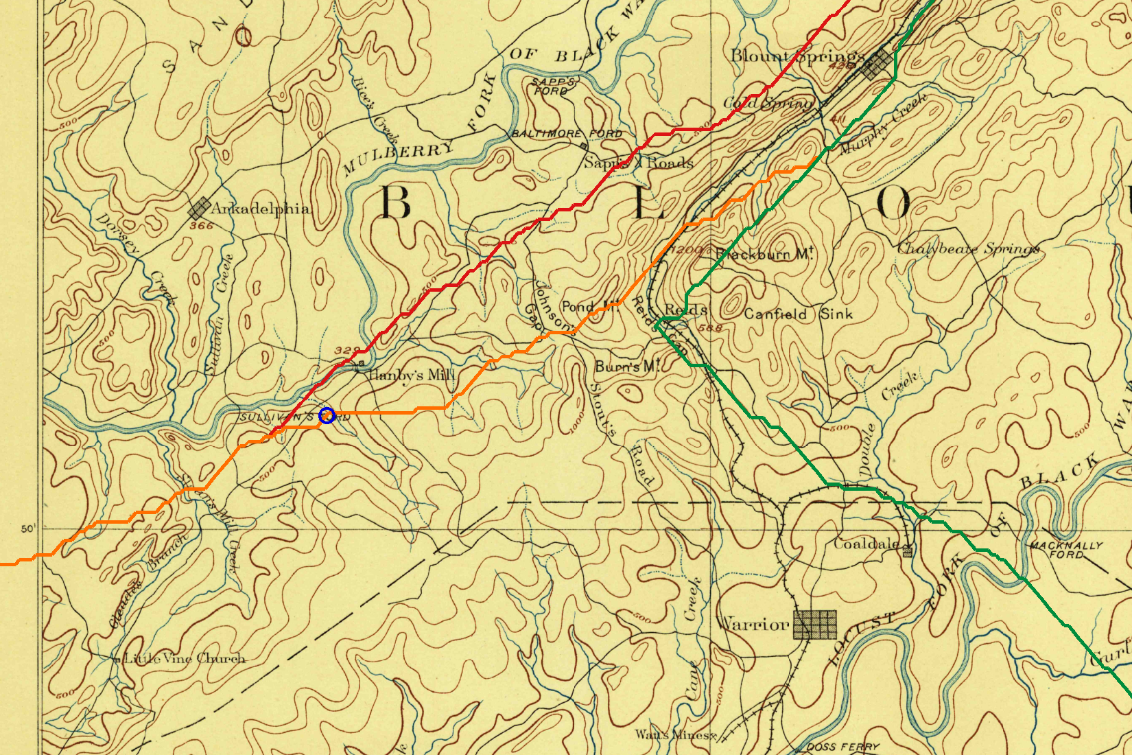
Finally I tried something different. A traveler on foot takes the easy way. So I asked a computer to walk the country: I gave it USGS elevation data, the rivers, and Tobler’s hiking function (a standard formula for how slope slows a walker), and asked for the cheapest route from Blountsville to the town. Forced through Blount Springs, the cheapest route added only about twelve minutes. It ran down the valley, went past Reid Gap within about six-tenths of a mile, took the gap country west, and passed right through Hanby’s Mill. The route that detoured through Old Baltimore was the costly one. The model does not know anything about history. It simply agreed with the maps.
Where I have landed
Here is what I think, and I want to be clear about the line between what I can document and what I believe.
What the documents establish. A Black Warrior Road existed in 1813, was known by that name, and went to a Creek town at the junction of the Sipsey and the Mulberry. Melish drew it in 1818 as one road to one destination, starting at the Brown’s Valley end of the county. In 1864 and 1889, a road system leaves the valley by Blount Springs and Reids, goes through a notch to Hanby’s Mill and on to the junction. A different road, Stout’s Road, crosses the Mulberry at Baltimore and heads for Jones Valley.
What I believe. The Black Warrior Road came down Brown’s Valley on the southeast side of the Mulberry Fork, passed through the Blount Springs and Reids country, turned west through the gap country to Hanby’s Mill, and ran to the junction on the same bank. A walker takes the valley. The railroad took it too, which is why I think the old grade on my land may sit on top of the old path. The Jones Valley road, the one we usually call the Black Warrior Road, is a later road that shared the corridor for part of the way and then went another direction.
What I cannot yet prove. The exact trace across any particular piece of ground. For that I need three documents I have not yet laid eyes on: the surveyors’ field notes for these townships, the county court’s road orders from the 1820s and 1830s, and the report of the commissioners Beaty, Winston and Adams, appointed in 1818 to find a route from the falls of the Black Warrior to the Tennessee River. Any one of them could settle it.
If you have an old road bed that crosses your land in this country, a deed that mentions “the Black Warrior road,” or a family paper that names Stout’s Road, Johnson’s Gap or Sapp’s Crossroads, I would like to hear about it.
Sources
John Melish, Map of Alabama (Philadelphia, 1818), Alabama Department of Archives and History. • John Coffee to Andrew Jackson, October 22, 1813, Andrew Jackson Papers, Library of Congress; Jackson to W. B. Lewis, October 24, 1813, Library of Congress; “Letters of General John Coffee to his Wife, 1813-1815,” Tennessee Historical Magazine II (1916), archive.org. • “Black Warrior Town / The Escape” marker, Sipsey Heritage Commission, 2017. • American State Papers: Indian Affairs, vol. II (1834), pp. 104-105 and 112-113, archive.org. • Treaty with the Cherokee, September 14, 1816, TNGenNet transcription; Charles C. Royce, The Cherokee Nation of Indians (1887), Project Gutenberg. • Acts of the Alabama Territory, 1st session, 1818, Alabama Legislature. • George Powell, “History of Blount County” (1855), transcription. • Newberry Library, Atlas of Historical County Boundaries, Alabama. • General Land Office plats, Huntsville District plat book vol. 2, Alabama Department of Archives and History. • U.S. Geological Survey, Birmingham sheet (1889) and Sipsey and Blount Springs quadrangles (1949, 1951), USGS Historical Topographic Map Collection. • Alabama Department of Environmental Management, Black Warrior River Basin report. • Related: Reid’s Gap, Blount Springs, Hanby Mill, Colonel Richard Brown.