


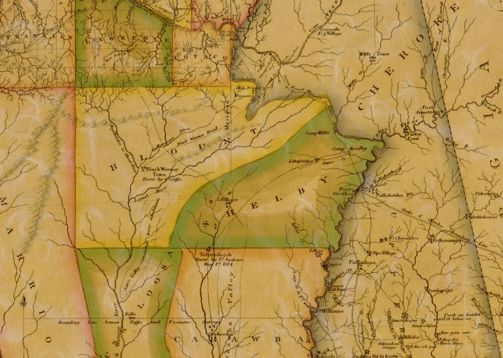
Before the railroad or any settlement, this stretch of hills was Upper Creek (Muskogee) territory. In 1813-14 the Creek War split the nation between the Red Stick faction and the United States. One of its earliest actions in this part of Alabama was the burning of Black Warrior Town, at the fork of the Mulberry and Sipsey near present-day Sipsey, in October 1813. The war ended nearly a year later, in August 1814, with the Treaty of Fort Jackson, which ceded Creek land in Alabama without yet forcing removal.
The Black Warrior Road, an old trading path, ran along the ridge behind what would become Smoke Rise, connecting Ditto’s Landing near Huntsville down to Black Warrior Town at the fork of the Mulberry and Sipsey.
The burning of Black Warrior Town
Black Warrior Town stood on the eastern side of the confluence of the Sipsey and Mulberry forks - one of the northernmost settlements of the Muscogee (Creek) Nation. It sat near the meeting point of Creek, Choctaw, and Chickasaw territory, and served as a place where members of the three nations came together to trade and to rest from hunting.
In October 1813, early in the Creek War, Andrew Jackson ordered the town destroyed. Colonel John Coffee led the detachment sent to do it, and David Crockett, then serving as a scout, rode with it. Writing to his wife from camp on 13 October, Coffee said he would set out the next day “with about 600 of my Regt” - Crockett, recalling it twenty years later, put the force at about 800. Coffee crossed the Tennessee at the upper end of the shoals and struck south on a path his guide - one of Melton’s sons, who admitted he did not know the country - told him “had been reputed the Black Warriors path.” He followed it about ten degrees east of south for eighty miles.

He burned more than one town. His report to Jackson describes two - thirteen miles west along a cross path, a small village with corn standing in the fields and no one in it, where his men took about a hundred bushels and burned the houses; then, eight miles further on, the main town, also abandoned. Writing privately to his wife two days after getting back he said plainly, “I burnt three towns but never saw an Indian.” Jackson too wrote of “the black warior Towns,” plural. In Crockett’s telling, written twenty years later, “when we arrived we found the Indians had all left it.” They took corn from the fields and old corn from the cribs - about three hundred bushels in all - and burned the council house and some fifty other buildings. Reporting to Jackson, Coffee wrote that the only other trace of the people who had lived there was “fresh fish of One or two Indians, and no other signs.” Jackson, writing from Fort Deposit two days later, put it shortly: “Colo. Coffee has Just returned, after burning the black warior Towns, and eating up their corn, and some of their beef.”
Coffee never recorded the day the town burned, but his own letters fix the expedition closely around it. On 13 October he was still camped on the Tennessee, two miles above Ditto’s Landing, writing that he would leave “tomorrow”; he set out, then, on the 14th. He was gone ten days, covering about two hundred miles there and back over country none of his guides knew. By noon on the 22nd he was on the march home and two days out of rations, and on the 24th he wrote that he had “this moment arrived” back at headquarters. That places the burning in the week of 18 to 22 October 1813. The marker at the site gives daybreak on 13 October, which cannot be right - on that day Coffee had not yet started.
How the town came to be empty is local history rather than documented record, and the accounts agree neither with each other nor with Coffee. The marker credits Chief Oceochemotla with maneuvering his people around the militia, has the militia camping on the surrounding ridges and attacking at daybreak, and says fires still burned and food sat uneaten. The Sipsey Heritage Commission, which erected that marker, has since published a fuller version: that most of the town had already left for what is now Cordova, while the elderly chief Black Warrior and four or five other elders stayed behind through the night keeping fires burning so the place would look occupied, and that Black Warrior was killed at dawn. Neither account names a source. Coffee’s own report describes none of it - no ridge camp, no attack, no chief, no one killed. He wrote only that “seeing that the Indians had fled I deemed it not adviseable to go further” - and, to his wife, more flatly still: “I burnt three towns but never saw an Indian.”
The town’s location is not universally agreed either, and the disagreement is as old as the campaign itself. Eighty miles out, Coffee crossed a river about sixty yards wide and came to a small deserted village that his guide Russell identified as Black Warrior’s town. Coffee overruled him - “being convinced it was not” - and pressed on another twenty-three miles to the town he did burn. Much of the wider literature on the Creek War places “Black Warrior’s Town” at the Falls of the Black Warrior, at present-day Tuscaloosa, and Crockett himself later put it there; the marker at the Sipsey site addresses that directly, calling it an error or a deliberate misdirection on his part. The identification used here, at the Sipsey and Mulberry confluence in what is now Walker County, is the one held locally and marked on the ground - and it is much older than the marker. Writing in the 1880s, Mary Gordon Duffee recorded that Jackson had detached Coffee’s brigade “to conquer Old Town on the east side of the junction of the Sipsey River and the Mulberry Fork of the Warrior,” the same spot the marker describes more than a century later. She adds that the site had by then become part of a farm held successively by the Pledgers, Samuel Acton and Isaac Johnston, with pottery and arrowheads still turning up on it.

A letter of Andrew Jackson’s, cited by Bhamwiki, describes the Creeks living at Black Warrior Town as refugees themselves - from Coldwater Town, a Chickamauga (Lower Cherokee) village at Tuscumbia landing on the Tennessee River, destroyed by Tennessee militia under General James Robertson in 1787.
Coffee’s letter home also gives the raid a purpose beyond corn. He calls them “the Black Warrior Towns, where Mrs. Crawley was carried” - Martha Crawley, taken captive in a Creek raid at the mouth of the Duck River in Tennessee in the spring of 1812 and later released through the efforts of a trader named Tandy Walker. Her captivity was used across Tennessee as a reason for war. Accounts differ on where she was held, some placing it at the Falls of the Black Warrior instead, so the detail does not settle the question of location either.
One line in Coffee’s report reaches into another story on this site. Writing on the way back, he placed himself about thirty miles from “Dick Browns” - Richard Brown, the Cherokee colonel who after the war settled a refugee Creek colony in the valley that came to bear his name (see Brown’s Valley and the Death of Stooka).
One last piece belongs to the site, offered on the marker as legend rather than history: that when Crockett fell ill while traveling through the area in 1816, he was warned in a dream never to return to the village he had helped burn.

Removal, 1832-1836
Removal accelerated after the 1832 Treaty of Cusseta allotted Creek land to individual families, many of whom were then defrauded or driven off by speculators and settlers. The resulting 1836 Creek War ended in the forced removal of the Creek Nation to Indian Territory - a Trail of Tears that, proportionally, killed a higher share of the Creek and allied peoples than the better-known Cherokee removal.
From trading path to stagecoach line
The same route didn’t disappear with removal - it became busier. Andrew Jackson’s Creek War campaign passed directly through this corridor in 1813-14, and many of his men returned afterward as some of Blount County’s first white settlers, founding a trading post at what became Blountsville. By 1818 the old trail had been surveyed and improved into the Huntsville Road (also called Bear Meat Cabin Road or Stouts Road), and in 1822 it was designated a federal post road - the main overland stagecoach route between Cincinnati and New Orleans, and the road that carried the Huntsville-to-Tuscaloosa stage line through the heart of Blount County.
A stagecoach needed fresh horses every few hours, so stops and taverns grew up along the route. The Barclift Inn (originally Hendricks Tavern), built around 1834 in Blountsville, is the oldest surviving building in town and is listed on the Alabama Register of Landmarks and Heritage - a two-story structure with wide balconies where passengers stayed the night and mixed with locals. Farther south, the line dropped wealthy travelers directly at the Blount Springs resort. Local tradition also holds that travelers along this stretch regularly stopped to drink from Blue Spring.
The stagecoach network through Alabama was run by large regional operators - most notably Jemison, Ficklin, Powell and Companies. The Jemison here is Robert Jemison Jr. (1802-1871), an antebellum Tuscaloosa businessman who built one of the largest stagecoach and mail-contract operations in the South, along with toll roads, toll bridges, and plank roads - not to be confused with his grandnephew of the same name, the real-estate developer behind Birmingham’s Mountain Brook more than half a century later (see The First Mount Brook Was in Blount County). The stage lines wound down through the late nineteenth century as the L&N Railroad expanded into the county - the same railroad that would go on to reroute past Blount Springs and Reid’s Gap decades later.

The road itself is still traceable today, running through private property and backyards along its route.
Sources: Bhamwiki, “Black Warrior Road”; Bhamwiki, “Black Warrior Town”; “Black Warrior Town / The Escape” historical marker, erected 2017 by the Sipsey Heritage Commission and the Alabama Tourism Department (Historical Marker Database); Sipsey Heritage Commission, “History”; David Crockett, A Narrative of the Life of David Crockett (1834), chapter 6; John Coffee to Andrew Jackson, October 22, 1813, and Andrew Jackson to William B. Lewis, October 24, 1813, in the Andrew Jackson Papers, Library of Congress; “Letters of General John Coffee to his Wife, 1813-1815,” ed. John H. DeWitt, Tennessee Historical Magazine II (1916), 264ff; Mary Gordon Duffee, Sketches of Alabama (University of Alabama Press, 1970), 19, 51-52; Bear Meat Cabin Road Historical Marker; Wikipedia, “Robert Jemison Jr.” (1802-1871).